REGIONAL INDEX
REG-0012
EDGE OF MEASURE
THRESHOLD MEASUREMENT REGION
No confirmed archive limit has been documented.
CLASSIFICATION
Threshold Measurement Region
TOPOLOGY
Continental Survey Escarpment
SIGNAL CONDITION
Distance Divergence / Measurement Instability
OBSERVER CONDITION
Extended observation may produce scale disagreement events
ARCHIVE STATUS
Active Survey
KNOWN STRUCTURAL STATE
Partially Verified

ENVIRONMENTAL DESCRIPTION
Edge of Measure marks the furthest verified extent of continuous archive surveying. The terrain presents as a broad mineral plain interrupted by isolated fracture systems and discontinuous geological boundaries.
Environmental continuity remains largely stable; however, attempts to establish definitive regional termination repeatedly produce conflicting survey results.
Distance measurements, directional reference, and boundary localisation become progressively inconsistent toward the outer survey sectors.
No confirmed archive limit has been documented.
TOPOLOGY / SIGNAL CONDITIONS
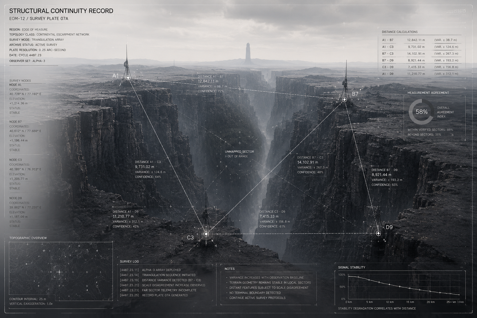
EM-TOP-0001
TOPOLOGY RECORD
Primary escarpment systems maintain consistent geological continuity throughout surveyed sectors.
Distance calculations beyond major canyon boundaries produce increasing variance between observation cycles.
Independent survey operations frequently return conflicting scale measurements despite identical environmental conditions.
No verified terminal boundary has been documented.
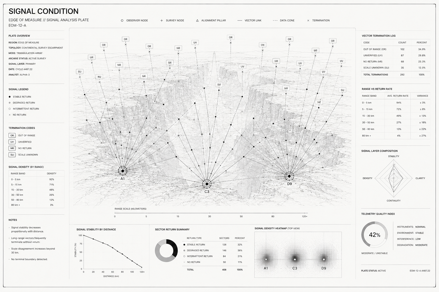
EM-SIG-0001
SIGNAL RECORD
Measurement stability decreases proportionally with observation distance.
Long-range survey operations frequently return incomplete or conflicting telemetry.
Scale agreement remains highest within verified archive sectors.
Environmental signal continuity remains active but unresolved beyond mapped boundaries.

EM-OBS-0002
OBSERVATION RECORD
Simultaneous survey systems produced conflicting distance calculations for a fixed landmark.
Observed variance exceeded acceptable archive tolerance by 312%.
Visual confirmation remained stable throughout the event.
ASSOCIATED ENTITIES

ARCHIVIST
Autonomous observation systems continue measurement operations beyond verified survey sectors.
Archive confidence progressively decreases with distance from the observer's origin.
Recovery operations remain ongoing.

ANOMALY RECORDS
EOM-ANM-0001
RANGE DIVERGENCE
Independent survey arrays produced conflicting distance calculations for identical reference points.
No consensus measurement could be established.
EOM-ANM-0002
SCALE UNCERTAINTY
Observed terrain maintained visual consistency while dimensional measurements fluctuated between observation cycles.
No stable scale reference has been verified.
EOM-ANM-0003
HORIZON DISPLACEMENT
Triangulation records indicated positional disagreement despite an unchanged visual horizon.
No environmental movement was detected.
EOM-ANM-0004
NULL RETURN
Survey vectors extending beyond verified archive boundaries failed to produce measurable environmental data.
No terminal survey point has been recovered.
ARCHIVE RECORDS
EM-OBS-0004
The eastern corridor was repeated after departure.
EM-SRV-0003
Marker orientation differed between observation cycles.
EM-RCV-0007
Structural agreement was never achieved.
DOCUMENT TYPES
OBS — Observation Record
SRV — Survey Record
RCV — Recovery Archive
ENT — Entity Encounter
ANM — Anomaly Record
SIG — Signal Record
ENVIRONMENTAL EVENTS
EVENT REGISTRY
EM-EVT-0001
FIRST MEASUREMENT DISAGREEMENT
CURRENT STATUS
Restricted
ASSOCIATED RECORD
EM-ER-0002
SUMMARY
The earliest archive record documenting conflicting range calculations from identical observation points.
EM-EVT-0003
HORIZON VERIFICATION EVENT
CURRENT STATUS
Stable
ASSOCIATED RECORD
EM-ER-0004
SUMMARY
Long-range observation program initiated to establish a fixed reference horizon. Verification remained inconclusive.
EM-EVT-0002
TRIANGULATION FAILURE
CURRENT STATUS
Stable
ASSOCIATED RECORD
EM-ER-0003
SUMMARY
Multiple survey networks produced mutually exclusive spatial solutions for a single canyon sector.
EM-EVT-0004
DEEP RANGE EXPEDITION
CURRENT STATUS
Restricted
ASSOCIATED RECORD
EM-ER-0005
SUMMARY
First successful traversal beyond established survey boundaries. Numerous distance records were archived as unresolved.

STATUS
Verified
INDEX
EM-0012
REG-0000
REGISTRY
CONNECTED REGIONS
REG-0010
OBSIDIAN MOUNTAINS
────────
REG-0001
ECHO FAULTS
────────
REG-0018
BOUNDARY VERGE
DESCENT / EXIT