REGIONAL INDEX
REG-0012
DATUM NETWORK
PLANETARY CALIBRATION FRAMEWORK
A distributed structural system has been identified beneath multiple geological regions.
CLASSIFICATION
Distributed Calibration Network
TOPOLOGY
Subsurface / Transregional
SIGNAL CONDITION
Stable Reference / Local Variance
OBSERVER CONDITION
Scale dependent
ARCHIVE STATUS
Active Survey
KNOWN STRUCTURAL STATE
Partially Verified

ENVIRONMENTAL DESCRIPTION
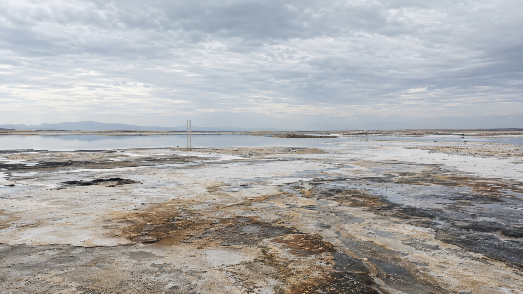
The Datum Network is a distributed structural system embedded within the geological substrate of multiple surveyed regions.
Surface manifestations occur intermittently as paired vertical structures designated Datum Pairs. Each consists of two narrow fins separated by a consistent interval. Exposed surfaces acquire the mineral characteristics of the surrounding terrain, making individual structures difficult to identify beyond close observational range.
Geological processes appear to determine exposure. Recorded pairs range from near-complete surface emergence to partial traces visible only through erosion or sediment displacement.
No complete section of the Network has been recovered.
Long-range survey indicates that individual Datum Pairs form larger positional relationships extending beyond regional boundaries.

DN-STR-0001
DATUM PAIR
Paired structural exposure associated with the Datum Network.
Each recorded instance consists of two narrow fins maintaining a fixed internal separation.
Outer surfaces exhibit mineral deposition, erosion, and staining consistent with surrounding geology.
Opposing internal surfaces remain planar.
No mounting structure or foundation has been recovered.
TOPOLOGY / SIGNAL CONDITIONS
DN-TOP-0001
TOPOLOGY RECORD
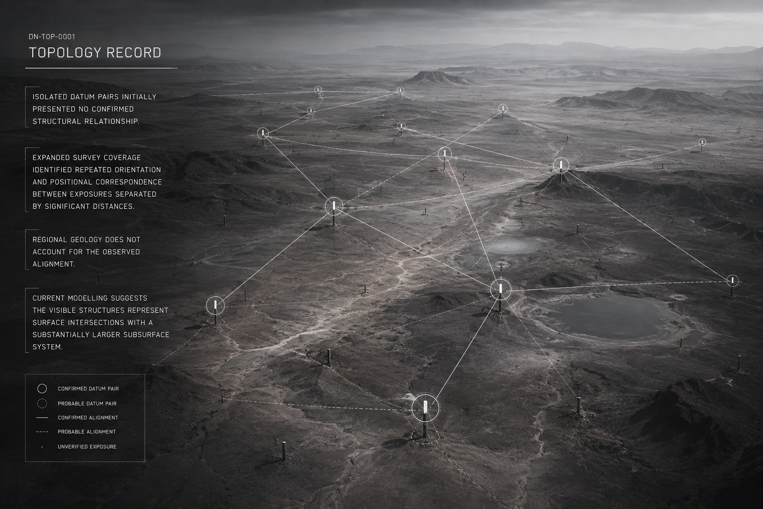
Isolated Datum Pairs initially presented no confirmed structural relationship.
Expanded survey coverage identified repeated orientation and positional correspondence between exposures separated by significant distances.
Regional geology does not account for the observed alignment.
Current modelling suggests the visible structures represent surface intersections with a substantially larger subsurface system.
DN-SIG-0001
SIGNAL RECORD
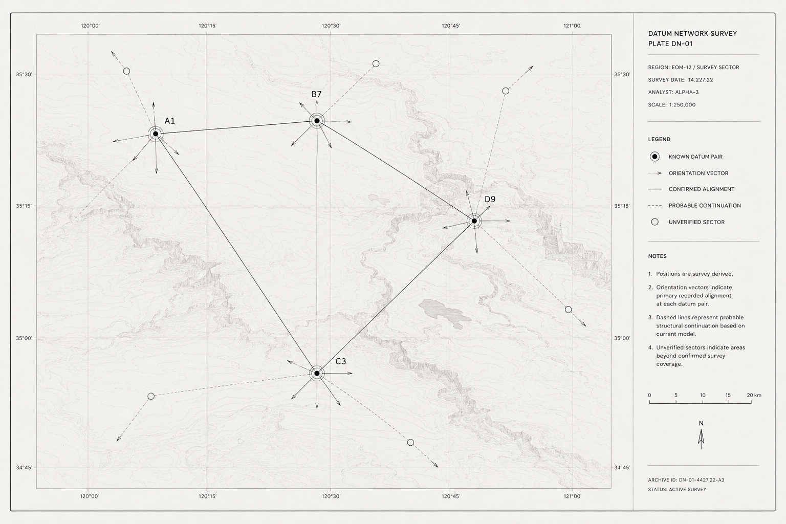
Measurement stability decreases proportionally with observation distance.
Long-range survey operations frequently return incomplete or conflicting telemetry.
Scale agreement remains highest within verified archive sectors.
Environmental signal continuity remains active but unresolved beyond mapped boundaries.

DN-OBS-0002
OBSERVATION RECORD
Survey systems recorded consistent visual confirmation of Datum Pair exposures across separated sectors.
Distance measurements between aligned pairs produced significant variance beyond accepted archive tolerance.
Orientation remained stable relative to observed alignments.
Current data indicates the structures form part of a distributed network extending beyond regional boundaries.
ASSOCIATED ENTITIES

ARCHIVIST
Archivist observations have extended Datum mapping beyond human survey range.
No direct interaction between Archivist systems and Datum structures has been recorded.
Whether the Archivist possesses additional knowledge of the Network remains unresolved.
ANOMALY RECORDS
DN-ANM-0001
RANGE DIVERGENCE
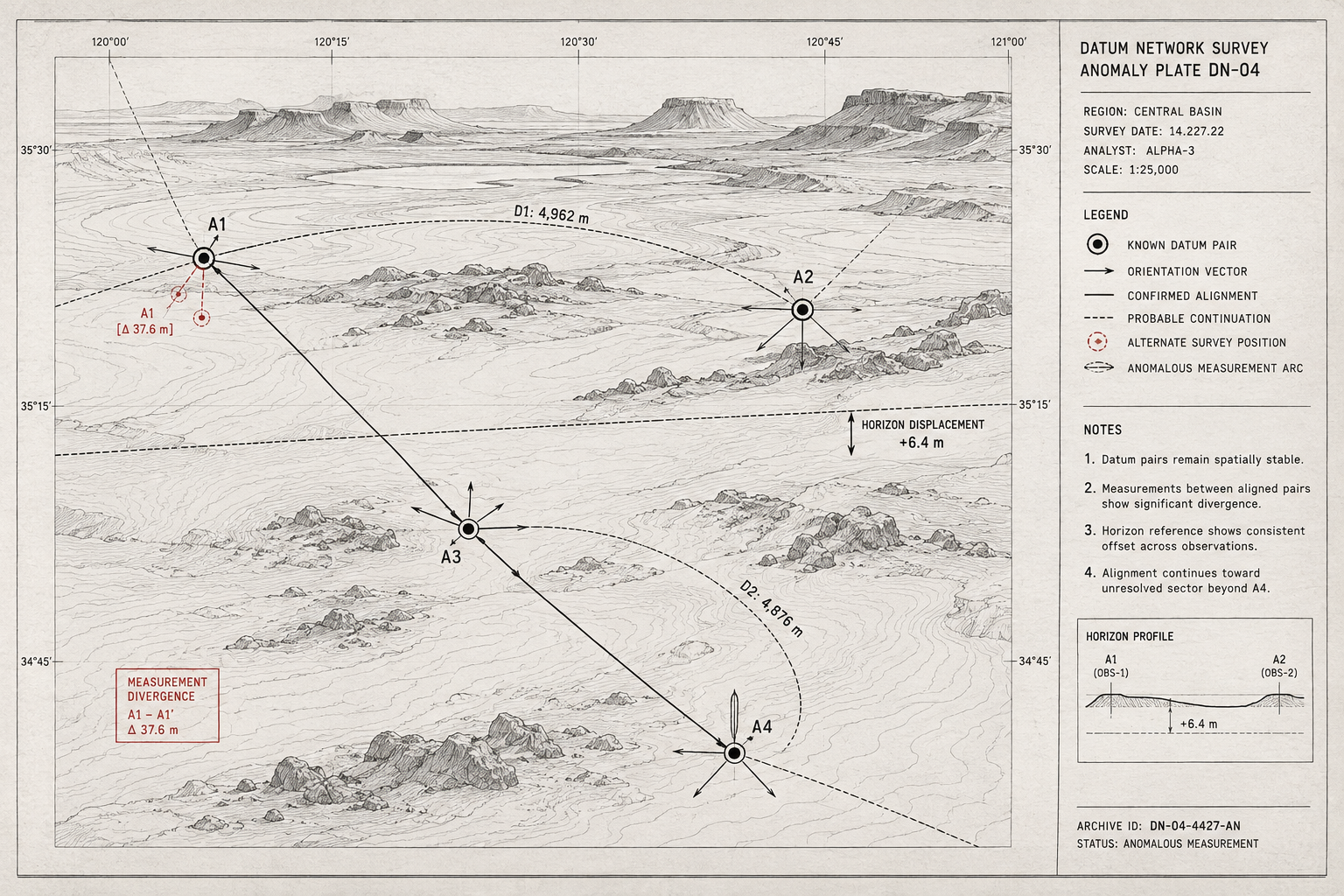
Measurements between known Datum Pairs produce conflicting distances.
DN-ANM-0002
SCALE UNCERTAINTY
Physical dimensions remain visually stable while survey scale changes between observation cycles.
DN-ANM-0003
HORIZON DISPLACEMENT
Datum orientation remains stable while the observed horizon fails to maintain positional agreement.
DN-ANM-0004
EDGE OF MEASURE
Survey extension beyond a specific Datum alignment repeatedly fails to produce a stable spatial solution. Instrumentation remains operational.
Datum references remain detectable.
No consistent measurement beyond the affected boundary has been established.
ARCHIVE RECORDS
DN-OBS-0004
Repeated Datum Pair formations have been documented across geographically separated survey sectors. Pair spacing varies between sites. Internal orientation remains consistent.
DN-SRV-0003
Exposed Datum structures are compositionally continuous with the surrounding regional geology. No introduced construction material has been identified.
DN-RCV-0007
Comparative survey data indicates that isolated Datum Pairs form part of a continuous system extending beneath multiple environments. The full extent and origin of the network remain unresolved.
DOCUMENT TYPES
OBS — Observation Record
SRV — Survey Record
RCV — Recovery Archive
ENT — Entity Encounter
ANM — Anomaly Record
SIG — Signal Record
ENVIRONMENTAL EVENTS
EVENT REGISTRY
DN-EVT-0001
FIRST DATUM IDENTIFICATION
CURRENT STATUS
Restricted
ASSOCIATED RECORD
DN-ER-0002
SUMMARY
The point at which two previously independent structures were recognised as related.
DN-EVT-0003
DEEP RANGE SURVEY
CURRENT STATUS
Stable
ASSOCIATED RECORD
DN-ER-0004
SUMMARY
High-altitude observation reveals relationships extending beyond a single region.
DN-EVT-0002
FIRST ALIGNMENT CONFIRMATION
CURRENT STATUS
Stable
ASSOCIATED RECORD
DN-ER-0003
SUMMARY
A third pair establishes that the structures belong to a larger geometry.
DN-EVT-0004
EDGE OF MEASURE
CURRENT STATUS
Restricted
ASSOCIATED RECORD
DN-ER-0005
SUMMARY
The first documented failure to reconcile Network geometry beyond a verified alignment.

STATUS
Verified
INDEX
DN-0012
REG-0000
REGISTRY
CONNECTED REGIONS
Multiple surface regions documented.
Regional classification pending.
DESCENT / EXIT